Copyright ©APKDroid. All Rights Reserved
Scarica SkyDemon - v3.14.5
| Package Name | aero.skydemon.skydemonandroid |
|---|---|
| Category | App, Mappe e navigatori |
| Latest Version | 3.14.5 |
| Get it On |

|
| Update | October 27, 2020 (5 years ago) |
Scarica e condividi SkyDemon - v3.14.5, uno degli elementi in primo piano App nella categoria Mappe e navigatori.
Inoltre, qualche altro App che puoi scaricare come Hammer Truck GPS Navigation App, Maps, & Routes, GPS Emulator Pro APK v1.59 MOD APK,
Sygic GPS Navigation & Maps v20.8.12-1769 APK + MOD (Premium Subscription)
MOD APK, Locus Map Pro Outdoor GPS navigation and maps APK Paid MOD APK, Relief Maps - 3D GPS Hiking | Trail Running | Ski, Genius Maps Offline GPS Navigation. Se sei soddisfatto di SkyDemon - v3.14.5.
Rilasciata da Divelements Limited, SkyDemon - v3.14.5 è una delle migliori applicazioni gratuite per telefoni cellulari attualmente disponibili. Si trova nella categoria Mappe e navigatori dell'app store.
Il sistema operativo minimo per SkyDemon - v3.14.5 è Android 4.0.3+ e versioni successive. Quindi devi aggiornare il telefono se non l'hai già fatto.
Su APKDroid, riceverai SkyDemon - v3.14.5 download gratuito di APK, con l'ultima versione 3.14.5, data di pubblicazione 2020-10-26, la dimensione del file è 39.3 MB.Secondo le statistiche del Google Play Store, ci sono circa 1000 download. Le app scaricate o installate singolarmente su Android possono essere aggiornate se lo desideri. Aggiorna anche le tue app. Ti garantisce l'accesso alle funzioni più recenti e alla sicurezza e stabilità dell'app. Divertiti subito !!!
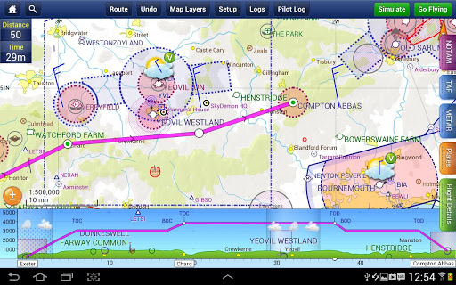
SkyDemon is one of Europe's most popular solutions for VFR flight planning and in-flight navigation.
Use this app to access your SkyDemon subscription on your Android device, unlocking SkyDemon's powerful features while on the move.
FLIGHT PLANNING FEATURES
- SkyDemon vector charts are the clearest aeronautical charts you'll ever use, with dynamic airspace clipping and choice of map layers
- Route planning is as simple as touching consecutive waypoints and dragging to make changes
- Virtual Radar shows how your route relates to airspace, terrain, obstructions and other features
- Pilot Log facility calculates headings and groundspeeds from actual wind data, and shows useful frequencies
- Plates and other documents for relevant airfields are displayed automatically as you plan, and many are available georeferenced for use in flight
- Intuitive pan, pinch and rotate support with no loss of map clarity or text legibility
- File a VFR flightplan for your route directly to air traffic controllers
- Automatic TAF, METAR and SIGMET briefing as you plan a route, with graphical decoding
- Rainfall data can be overlaid on the main map, with animation, showing the trend of rainfall over time
- Integration of GAFOR route forecasts for Switzerland, Austria, Slovenia and Croatia
- Both narrow-route and area NOTAM briefings available, updated as you plan
- Advanced NOTAM graphical interpretation and depiction on the main map
- Easily print your PLOG and the output from various briefings
- Warnings for airspace and other potential hazards to your flight, updated in real time
- Airfield Admin Information shows useful contacts and other details for airfields featured in our charts
- Forecast winds aloft are automatically retrieved for the flight time and displayed on the map
- Create an advanced flight performance profile for each aircraft you use
- ATS Routes mode offers an alternative chart presentation for flight along airways
- Accurate fuel, weight and balance calculations including flight costings
- Create an unlimited number of user-defined waypoints
- Analyse your track logs for posterity
- Choose between six different vector chart styles
- Extensive European chart coverage as standard
GPS NAVIGATION FEATURES
- Intelligent warnings for approaching airspace, NOTAM, obstacles, terrain and other hazards
- Virtual Radar shows a side-on projection of all approaching features and how your trajectory relates to them
- Vector map automatically follows the aircraft in north up, track up or course up orientation
- Clear and concise instruments show you flight statistics and help keep you on track
- An HSI/ILS instrument helps you keep to your planned route and line up early for approach
- Live Pilot Log shows progress through your route, ETAs, ATAs and useful frequencies based on your current position
- TerrainSafe dynamically colours mountainous terrain around you to quickly identify safer areas
- Direct To allows easy re-routing in a hurry by picking from a selection of nearby airfields
- Approach Information shows runway diagrams, TAF, METAR, NOTAM and other airfield details useful for making an approach
- Live updates of TAF and METAR while in flight, with associated alerts*
- Extended runway centrelines appear automatically on the map as you near your destination airfield
- Permanent display of position relative to nearest well-known waypoint, for position reporting
- Easy changing of the planned route while in flight by touching and dragging
* Internet connection required for live weather update while in flight
- Airspace Use Plan (AUP) data is now integrated into SkyDemon
Show more