Copyright ©APKDroid. All Rights Reserved
Tải về ALTLAS Trails & Maps: Walking trails & Elevation - v3.0.1
| Package Name | altitude.alarm.erol.apps |
|---|---|
| Category | Ứng dụng, Bản đồ & Dẫn đường |
| Latest Version | 3.0.1 |
| Get it On |

|
| Update | October 18, 2021 (3 years ago) |
Hãy tải xuống và chia sẻ ALTLAS Trails & Maps: Walking trails & Elevation - v3.0.1, một trong những Ứng dụng nổi bật trong danh mục Bản đồ & Dẫn đường.
Thêm nữa, một số Ứng dụng mà bạn có thể tải tải về khác như Genius Maps Offline GPS Navigation, Lalamove Driver - Earn Extra Income, Radarbot (MOD, Premium Đã mở khóa) MOD APK,
Sygic GPS Navigation & Maps v20.8.12-1769 APK + MOD (Premium Subscription)
MOD APK, Wikiloc Outdoor Navigation GPS Premium APK MOD APK, Hammer Truck GPS Navigation App, Maps, & Routes. Nếu bạn cảm thấy chưu đủ với ALTLAS Trails & Maps: Walking trails & Elevation - v3.0.1.
Phát hành bởi Erol1Apps, ALTLAS Trails & Maps: Walking trails & Elevation - v3.0.1 là một trong những ứng dụng điện thoại di động miễn phí và tốt nhất hiện nay. Nằm trong danh mục Bản đồ & Dẫn đường của cửa hàng ứng dụng.
Hệ điều hành tối thiểu cho ALTLAS Trails & Maps: Walking trails & Elevation - v3.0.1 là Android 6.0+ trở lên.Do đó bạn phải cập nhật điện thoại của mình nếu chưa làm điều đó.
Tại APKDroid, bạn sẽ được tải về miễn phí ALTLAS Trails & Maps: Walking trails & Elevation - v3.0.1 APK, với phiên bản mới nhất là 3.0.1, ngày xuất bản 2021-10-17, kích thước file là 19.6 MB.Theo thống kê từ Cửa hàng Google Play, có khoảng 1000 lượt tải được. Có thể cập nhật các ứng dụng được tải xuống hoặc cài đặt riêng lẻ trên thiết bị Android nếu bạn muốn. Cập nhật ứng dụng của bạn cung cấp cho bạn quyền truy cập vào các tính năng mới nhất và cải thiện tính bảo mật và ổn định của ứng dụng. Hãy tận hưởng nó ngay bây giờ!!!
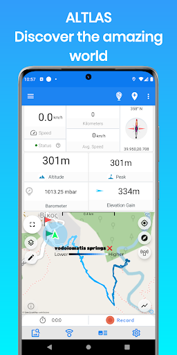
Explore, record, and share your activities, get the current elevation and tracking information with the Altimeter - Activity tracker. Find hiking trails, record your activities with the GPS, Import/export GPX trails.
Download the ultimate activity tool today!
ALT-LAS Can be used as a Bike computer use it on your bike, bicycle, scooter, and more!
By using the app you can get:
1. Elevation finder and activity tracker.
2. The app has a unique database of many trails around the world that was recorded by the users so you get the best hiking trails.
3. The app finds your altitude, peak points, barometric pressure, speed, and more!
4. The app alerts you against altitude limitations and is suitable for a variety of activities such as Walking, Trekking, Flights, Cycling, Skiing, biking, and more.
Have you ever searched for "walks near me?" or find elevation? now you can get it immediately with ALT-LAS.
Help build a community that shares routes and places around the world.
Measuring altitude modes:
1. GPS mode: the application measures the altitude using the GPS and performs a unique correction to provide an accurate altitude.
Note, the altitude readings may be inaccurate when the GPS signal is weak.
2. Barometer sensor (a device with a barometer sensor): the application can work with the device’s barometer sensor that is auto-calibrated with the environment.
In this mode, the application can work inside buildings without GPS.
Features:
- Altimeter to get your current altitude.
- Track activities
- Track your elevation
- Discover and share tracks
- Elevation map
- Compass with lock bearing
- Calories calculator
- Share live location (Subscription only)
- Real-time altitude graph
- Altitude limit alerts
- Save landmarks
- Barometric pressure
- Import/export GPX files
- Climbing information
- The Altimeter can work offline (flight mode)
- Get indoor/outdoors altitude
- Periodic altitude voice notification
- Different map types: Topographic, Open Street Map, hike & bike, and Satellite (Premium only).
- Sensor info (Supported devices only) such as Barometer, Temperature, Light, and Humidity.
- Dark mode
Planning and Navigation tools:
- Measure route and vertical distance
- Routing: get fastest route between any location to another.
- Get coordinates on the map
- Estimate time of arrival
- Circular boundary
SUPPORT:
For any questions or suggestions, feel free to contact us:
Check the Telegram channel where you can ask questions, ideas, request features, share your activities, and more: https://t.me/ALTLASAPP
Customer support:
[email protected]
Website:
www.altlas-app.com
Download the app now and get started!
The use of this app or any of its content is at your own risk.
If you liked the app, please rate it!
ALT-LAS keeps improving with new updates!1. Massive user interface change2. Improve performance 3. Bug fixes.Please let us know what do you think about the new user interface at [email protected]!
Show more